iPhoto for iOS is using OpenStreetMap instead of Google Maps marking the first time the company has used an alternate mapping solution, according to a blog post from OSM.
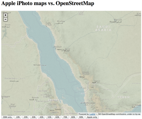
Yesterday Apple launched iPhoto, its photo management app, for the iPad and iPhone... and we're rather pleased to find they're the latest to switch to OpenStreetMap. The desktop version of iPhoto, and indeed all of Apple's iOS apps until now, use Google Maps. The new iPhoto for iOS, however, uses Apple's own map tiles – made from OpenStreetMap data (outside the US).
If you don't have iPhoto, you can view the maps using this unofficial viewer from Dair Grant or a transparent comparison from Ivan Sanchez. The OSM data that Apple is using is rather old (start of April 2010) so don't expect to see your latest and greatest updates on there. It's also missing the necessary credit to OpenStreetMap's contributors; we look forward to working with Apple to get that on there.
You can purchase iPhoto from the App Store for $4.99.
[via Marco]
Get the iClarified Daily Newsletter
Apple news, rumors, tutorials, price drop alerts, in your inbox every evening, free.
Unsubscribe at any time.
Success!
You have been subscribed.
Add Comment
Would you like to be notified when someone replies or adds a new comment?
Yes (All Threads)
Yes (This Thread Only)
No
Notifications
Would you like to be notified when we post a new Apple news article or tutorial?





![Apple-LG Home Accessories Could Offer Dynamic Island Proximity Controls [Leak]](/images/news/102711/102711/102711-160.jpg "Apple-LG Home Accessories Could Offer Dynamic Island Proximity Controls [Leak]")
![How To Force Restart iPhone [Video]](/images/tutorials/95012/95012/95012-160.jpg "How To Force Restart iPhone [Video]")
![How To Turn Off iPhone [Video]](/images/tutorials/94999/94999/94999-160.jpg "How To Turn Off iPhone [Video]")
![How To Back Up Your iPhone to an External Drive on Mac [Video]](/images/tutorials/72786/72786/72786-160.jpg "How To Back Up Your iPhone to an External Drive on Mac [Video]")






![Mac mini Drops to $779.99 for Prime Big Deal Days [Deal]](/images/news/102624/102624/102624-160.jpg "Mac mini Drops to $779.99 for Prime Big Deal Days [Deal]")
